Quality Control
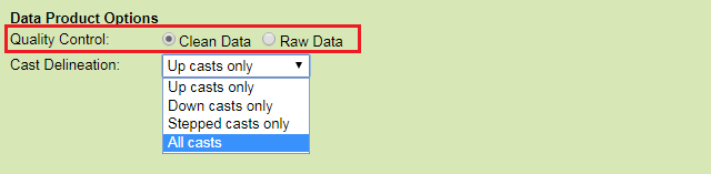
Raw Data
When this option is selected, raw data will be supplied in the data products: no action is taken to modify the data. In general, all scalar data is associated with a quality control flag. These flags are stored adjacent to the data values.
Oceans 3.0 API filter: dpo_qualityControl=0
Clean Data
Selecting this option will cause any data values with quality control failures (QAQC flags 3, 4 and 6) to be replaced with NaNs. “-clean” is added at the end of the filename.
Oceans 3.0 API filter: dpo_qualityControl=0
Cast Delineation / Breaks:
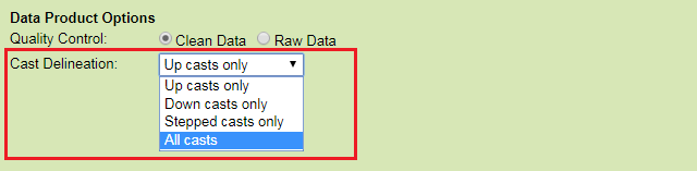
Up casts only
Only data collected while the profiler is ascending the water column are selected. Individual up casts are identified and stored separately within one final data structure for file data products. A plot be produced for each day consisting of all up casts that began during that day. The break time is not strictly midnight, it is 0800 UTC (midnight PST, 0100 PDT).
Oceans 3.0 API filter: dpo_cast=up_casts
Down casts only
Only data collected while the profiler is descending the water column are selected. Individual down casts are identified and stored separately within one final data structure. The time range specified will be broken up daily and a plot will be produced for each day consisting of all down casts that began during that day. The break time is not strictly midnight, it is 0800 UTC (midnight PST, 0100 PDT).
Oceans 3.0 API filter: dpo_cast=down_casts
Stepped casts only
Only data collected while the profiler is stepped mode are selected (currently unique to VPS). Individual stepped casts (all up casts and stationary segments during a stepped cast) are identified and stored separately within one final data structure. Individual plots will be produced for each stepped cast.
Oceans 3.0 API filter: dpo_cast=stepped_casts
All casts
Only data collected while the profiler is ascending, descending, or stationary in the water column are selected. Individual casts (up, down, stationary) are identified and stored separately within one final data structure. The time range specified will be broken up daily and a plot will be produced for each day consisting of casts (up, down, stationary) that began during that day. The break time is not strictly midnight, it is 0800 UTC (midnight PST, 0100 PDT).
Oceans 3.0 API filter: dpo_cast=all_casts
Mobile Position Sensor Integration Option
All scalar data products from mobile deployments have positioning data integrated into the their time series (where available/applicable) aside the target sensor or sensors (for device-level requests). Integration includes position (Latitude, Longitude, Depth) and orientation (Heading, Pitch, Roll).
This option will exclude orientation sensors from the mobile position integration in time series scalar file data products. The default option here can be many times faster as orientation data can have very high sample rates and be very slow to interpolate on to the target sensor time series (orientation data usually comes from optical gyroscopes on inertial navigation systems). Most scalar sensor measurements such as temperature, salinity and not sensitive to orientation and do not need orientation data. For directional / orientation sensitive data, such as current velocities, ONC standard practice is to correct that data to be relative to true North / horizontal, so orientation is redundant there as well. Orientation sensors are not excluded from any metadata, such as plot comments or the metadata structure in MAT file data products; this option only affects the integration of orientation data into the time series.
This data product option may appear on devices / deployments where orientation data is not available or applicable to the selected data product, for example, some time series scalar profile plots and drifter devices. In those cases, the option has no effect. All data products do document which options were applied in their file headers (as in this case) and/or in their file-names.

Depth / Latitude / Longitude sensors only (faster)
Oceans 3.0 API filter: dpo_includeOrientationSensors=0
All mobile position and orientation sensors (Depth / Latitude / Longitude / Heading / Pitch / Roll / etc. - slower)
Oceans 3.0 API filter: dpo_includeOrientationSensors=1