Kongsberg Mesotech Rotary Sonar Data Product - SWEEP Mode
Data files for Kongsberg Mesotech Rotary Sonar instruments are described here. In the sweep mode, the sonar does a 360 degrees sweep of the nearby water and seabed.
Revision History
- 20120519: Initial SMB product released
- 20121002: Scan Mode enabled
Formats
This data is available in SMB format (the log file is a internal Neptune Canada format). Log files are created daily at midnight UTC from data acquired throughout the day. Shortly thereafter, the data products are processed from the log files and are made available to data search. Content descriptions are provided below.
SMB
This binary format is specific to the manufacturer. When using Kongsberg Mesotech data acquisition software, data is normally stored in this way. Although we use custom-built drivers to communicate with our instruments, we can use the raw data in the log file to produce the SMB file which can be interpreted by Kongsberg Mesotech MS1000 post-processing software.
This format is further described in the manufacturer's documentation: 900-00007904-2.1.pdf. A MATLAB library is available upon request to read the SMB file. This code will be used to create a MAT file data product in the future.
Please note, this is a brand new data product. It has only been tested in MS1000 version 4.51 (testing is in progress with version 5.0). It's availability may be limited, there may be data gaps. Daily data processing will begin around July 11, 2012. Some recent data is currently available. Historic data will be reprocessed and will become available in the near future. If a data search returns with 'No data found' when the data availability shows that there is data, please contact NEPTUNE support and we will make that data a priority for processing.
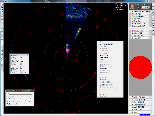
Viewing SMB Files
The MS1000 software (Kongsberg Mesotech, http://www.kongsberg-mesotech.com) is free to redistribute for playback of the data. Download the MS Windows version here: MS1000_V0520_unlocked.zip. Then unzip and run MS1000_V0520_Setup.exe. To view the data, run the MS1000 software and press the play button. Alternatively, double-click an SMB file to launch the software in playback mode. The fast-forward function is useful for viewing the data quickly.
Previous versions of the MS1000 software did not directly support the high sample high that our rotary sonars operate at. To make older versions work, right-click on the image and select 'Fit Image To Screen'.
MAT (COMING SOON!)
MAT files (v7) can be opened using MathWorks MATLAB 7.0 or later. The file contains four structures: meta, data, config, and units.
Meta: structure containing the following metadata fields.
- deviceID: A unique identifier to represent the instrument within the NEPTUNE Canada observatory.
- creationDate:Date and time (using ISO8601 format) that the data product was produced. This is a valuable indicator for comparing to other revisions of the same data product.
- deviceHeading: Obtained at time of deployment (exception: devices on mobile platform will have NaN since they do not have a fixed heading).
- siteName: Name corresponding to its latitude, longitude, depth position.
- deviceName: A name given to the instrument.
- deviceCode: A unique string for the instrument which is used to generate data product filenames.
- locationName: The node of the NEPTUNE Canada observatory. Each location contains many sites.
- samplingPeriod: Sampling rate of the instrument in seconds.
- depth: Obtained at time of deployment.
- lat: Obtained at time of deployment.
- lon: Obtained at time of deployment.
- dataProductVer: Version of data product.
Data: structure containing the ADCP data, having the following fields.
- time: vector, timestamp in datenum format (obtained from time the reading reached the shore station)
- range: vector of distance to start of each bin
- cellDepth: vector, starting depth of each cell calculated from range and deployment depth (may be inaccurate if instrument is vertically mobile)
- u,v,w: 2D matrices, East/North/Up velocities relative to True North, derived using raw velocity matrix, orientation, coordinate system, transformation matrix and one of a) calculated magnetic declination based on time and location (for mobile adcps) or b) meta.deviceHeading (fixed position ADCPs)
- velocity: 3D matrix, corresponds directly to output of instrument and so depends on configuration coordinate system
- amplitude: 3D matrix, amplitude time-series for each of the three receivers
- correlation: 3D matrix, signal correlation coefficient time-series for each of the three receivers (only available for HR-Profilers)
- compassHeading: vector, magnetic compass heading time-series
- pitch: vector, pitch time-series
- roll: vector, roll time-series
- pressure: vector, pressure time-series
- temperature: vector, temperature time-series
- soundSpeed: vector, sound speed time-series (often constant, depending on configuration)
- voltage: vector, battery voltage time-series
- error: vector, error code
Discussion
To comment on this product, click Add Comment below.