...
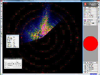
Data files for Kongsberg Mesotech Rotary Sonar instruments are described here. In the SCAN mode, the sonar repeatedly images a particular sector of the of its full 360 degree sweep range. The parameters are set with a central azimuth and a half-width. To see these settings, navigate to the device details from step 2 of data search, i.e. http://dmas.uvic.ca/DeviceListing?DeviceId=12007, and then go to the attributes tab. If the scan mode is not active, no scan data products will be generated. The full SWEEP data product is also available and is always active when the device is active. This is why users may find the sweep data product returning data, while the scan mode returns with a 'No data found' message. The availability of the scan mode data product may be less than that indicated by the data availability graph.
Oceans 23.0 API filter: dataProductCode=KSDP
...
- 20120519: Initial SMB product released
- 20121002: Scan Mode enableenabled
- 20140730: MAT-file and plotting products added
...
This format is further described in the manufacturer's documentation: 900-00007904-2.1.pdf. (Here's a more recent version: Singlebeam_SMB_V0230.pdf, however, our SMB format is based on the older format specification.) The MATLAB library we use to produce MAT file and plots from SMB files is available upon request. In the replication of the SMB file, the sonarAngle, also known as the startAngle from EXTRA_HIGH_FREQ_SONAR_TUPLE_DATA is corrected to a bearing relative to true North. The correction from instrument relative bearing to true bearing uses the following, in descending order:
- device true heading from Oceans 3.0 metadata, specified using a fixed heading or a mobile position sensor plus the sitedevice offset. For example: https://data.oceannetworks.ca/DeviceListing?DeviceId=11401 → site tab → https://data.oceannetworks.ca/Sites?siteId=1000659 where offset heading 181 degrees (site fixed heading is not required - only one of site heading or offset heading are, but are additive if both provided).
- onboard compass, if equipped (new for spring 2021). If the device attribute compass is "ON", the instrument driver software will poll the compass at the start of each SWEEP or SCAN and that data is passed into the SMB file as a DATA_TYPE_HDM tuple, specifying the magnetic heading. A declination correction is applied for the latitude of the device.
This differs from the operation of a rotary sonar onboard a moving vehicle using the MS1000 software: the compass or heading isn't applied to the startAngle, but instead MS1000 rotates the compass rose on the display, keeping the instrument axis pointed up. The compass data appears in the DATA_TYPE_HEAD_SENSORS tuple. In our use case, we're interested in the plot relative to true North, so North is always up. When running an ONC SMB file through MS1000 playback, the software fortunately ignores the compass data, plotting only the sonarAngle/startAngle, which is a true bearing so that the plot on screen is correct.
This data product has been tested mostly with MS 1000 version 4.51, while the new version, 5.2, also tests well. Historic data has been reprocessed and sweep SMB files files should be fully available. If a data search returns with 'No data found' when the data availability shows that there is data, please contact us and and we will be happy to investigate.
...
Previous versions of the MS1000 software did not directly support the high sample high rate that our rotary sonars operate at. To make older versions work, right-click on the image and select 'Fit Image To Screen'. To avoid doing this every time, best to "Save Settings" when prompted while closing the software. Some combinations of Windows OS and MS1000 may not work together; we've had some success with "Run as administrator" (right-click on the MS1000 icon to see that option) and/or running in compatibility mode (right-click on the icon, go to properties and then the compatibility tab).
In some cases, the software does not display the reverse direction of the scan very well. Wiggle your update the image promptly. Wiggle your mouse and the display will update. (It appears to be a limitation of the software and graphical capability of one's computer, we're investigating.) The fast forward function of the software is very useful to view a large amount of data quickly.
Oceans 23.0 API filter: extension=smb
...
Data: structure containing the Kongsberg rotary sonar data, tightly based on the tuple structure of SMB files. Only the important fields are listed below. For more information, refer to the SMB file specfication: 900-00007904-2.1.pdf. Please note that not all structures and fields available in the SMB files are converted and provided in the MAT file all of the time. If there is anything missing or something to be improved, please contact us, we'll be happy to make improvements.
...
Additional tuples for heading, location maybe added in the future.
Oceans 23.0 API filter: extension=mat
...
The algorithms for detecting each rotation and for making the plots are somewhat complex. Contact us if you are interested in the source code for these plots, which would be useful for analyzing the data from the MAT files.
Oceans 23.0 API filter: dataProductCode={png,pdf}
...
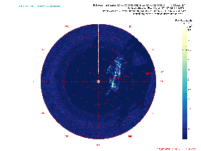
The GIF is a combination of PNG plots seen above excluding the sonar pointing / heading angle as a function of time plot. The GIF plots are broken up daily so they run through every PNG in a day.
Oceans 23.0 API filter: extension=gif
...